Identification of areas on old maps
Anonymous 01/03/25(Fri)14:52:30 | 8 comments | 1 images

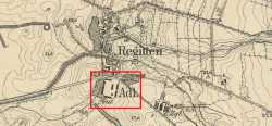
Anyone knows what that thing is? Its on old german map of the area, but there is nothing here currently. I dont know german so no clue what the writing means.
You can use this thread to ask about that kind of stuff too
You can use this thread to ask about that kind of stuff too
Anonymous 01/03/25(Fri)15:22:37 No.2798089

>>2798086
Gut in Adlig Regitten. It's a farm.
Gut in Adlig Regitten. It's a farm.
Anonymous 01/03/25(Fri)16:49:13 No.2798101
>>2798089
Oh well, you are right. Thanks
Oh well, you are right. Thanks
Anonymous 01/03/25(Fri)17:20:52 No.2798104
>>2798086
that's how they marked larger buildings on those maps anon, that style is very common from mid 1800's to 1930's.
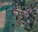
as the other anon showed you can quite clearly see several of the buildings still standing, as is the case in many european countries.
you can also see the farm house to the north across the road with its L shape still standing
Anonymous 01/03/25(Fri)21:24:08 No.2798133
>>2798101
What maladaptive daydreaming fantasy were you projecting on it?
What maladaptive daydreaming fantasy were you projecting on it?
Anonymous 01/03/25(Fri)21:24:39 No.2798134
>>2798133
A workshop maybe
A workshop maybe
Anonymous 01/14/25(Tue)10:25:50 No.2799990
>>2798086
Whatcha doing with it anon? Do you wanna be map frens?
Whatcha doing with it anon? Do you wanna be map frens?
Anonymous 01/15/25(Wed)11:49:53 No.2800216
>>2799990
Not OP, but are you into maps as a hobby? What do you do exactly? Am interested for urbex purposes.
Not OP, but are you into maps as a hobby? What do you do exactly? Am interested for urbex purposes.
Anonymous 01/22/25(Wed)01:20:34 No.2801634